

By Radek Oborny & Ni Nyoman Pujianiki
Faculty of Engineering, Udayana University, Bali, Indonesia

Presented & awarded at ICETSD conference at Udayana University on 17th August 2025.
Climate Change, Rain, and the Color of the Ocean
In recent years, Bali has seen wild swings in its rainy seasons — from drought-like dry spells to months of torrential rain. These extremes aren’t just uncomfortable for farmers or tourists — they also change the color and quality of the sea itself.

After particularly intense rain, the normally turquoise waters along Bali’s southwestern coast often turn brownish or orange, especially near river mouths. What’s happening? The answer lies in sediment — soil, silt, and organic matter washed into the sea by heavy rainfall.
This study set out to track those changes using Sentinel-2 satellite imagery and rainfall data from Indonesia’s BMKG Meteorological Agency.

🌊 Watching the Coast from Space
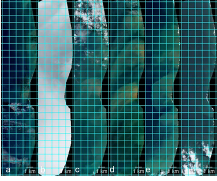
Our research focused on Bali’s southwestern coastline — from Antap to Kuta — where rivers like Yeh Ota, Yeh Poh, and Tukad Pangi flow from agricultural highlands into the Indian Ocean. These rivers carry sediments that can be seen from orbit, turning the sea from clear blue to murky brown.
Using Sentinel-2 L2A true-color images, we manually examined over 200 satellite captures between April 2022 and April 2025. Each image was rated for water clarity, discoloration intensity, and cloud cover — creating a “pollution factor” score for each location.
“Even from space, you can see Bali’s rivers painting the coastline after major rainstorm.”
☔ What the Rain Reveals
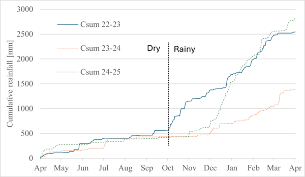
Rain data from BMKG stations in Denpasar, showed how rainfall intensity and timing varied dramatically from year to year.
- The 2023 rainy season was weak and delayed.
- The 2024–25 season brought intense, prolonged downpours — enough to overwhelm local drainage and stir up sediments.
By comparing rainfall with the satellite data, we found a statistically significant (though moderate) correlation between heavy rain and water discoloration. In other words — more rain generally meant murkier coastal waters.
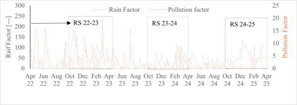

However, rainfall wasn’t the only factor. Land use, agricultural erosion, and riverbank management also played important roles.
🛰️ Remote Sensing: Power and Pitfalls
Remote sensing is a powerful way to observe environmental change at scale. It allows us to detect sediment plumes, pollution hotspots, and seasonal dynamics without ever dipping a bucket into the sea.
But it’s not perfect:
- Cloud cover hides the coastline for nearly half of all satellite passes during the wet season.
- The Sentinel-2 revisit time (about every 5 days) limits how fast we can track short-term events.
- Coastal areas are tricky — shallow waters and light reflection make color-based algorithms less reliable.
To fill those gaps, future monitoring should combine satellite data with in-situ sensors — such as IoT-enabled water buoys that measure turbidity and color in real time.
🔬 Toward Smarter Coastal Monitoring
The manually rated dataset from this study could serve as training data for AI models, allowing for automated detection of coastal discoloration events across Bali and beyond. With accessible platforms like Google Earth Engine, such analysis can be scaled up without heavy coding skills.
Ultimately, integrating satellite insights, rainfall data, and local sensor networks offers a holistic path to understanding — and protecting — Bali’s coastal ecosystems.
🌴 Why It Matters
For an island economy so tied to tourism and fisheries, water quality isn’t just an environmental concern — it’s a lifeline. Clear blue water means healthy reefs, thriving marine life, and a vibrant tourism industry.
But when extreme weather brings brown tides to shore, it’s a visible reminder of how connected our land use, weather, and oceans really are.
References & Further Reading
- Sentinel-2 Mission Overview – European Space Agency
- BMKG – Indonesia’s Meteorological, Climatological, and Geophysical Agency
- Flo-Bro Smart Buoy for Real-Time Water Quality Monitoring
- Remote Sensing of Ocean Colour – Review Article (Progress in Oceanography, 2014)
- I. G. A. P. Eryani, A. M. A. Manan, and M. W. Jayantari, “Comparative analysis of watershed characteristics in Bali province for sustainable water resources managemeng,” Indonesian journal of urban and environmental technology., 2021, doi: 10.25105/urbanenvirotech.v4i2.8862.
- D. Blondeau-Patissier, J. F. R. Gower, A. G. Dekker, S. R. Phinn, and V. E. Brando, “A review of ocean color remote sensing methods and statistical techniques for the detection, mapping and analysis of phytoplankton blooms in coastal and open oceans,” Prog Oceanogr, vol. 123, pp. 123–144, Apr. 2014, doi: 10.1016/J.POCEAN.2013.12.008.
- N. N. Pujianiki et al., “Monitoring and Analysis of Coastline Changes in the Coastal Area of Bali Island, Indonesia,” Civil Engineering Dimension, vol. 26, no. 1, pp. 32–50, Mar. 2024, doi: 10.9744/ced.26.1.32-50.
- M. Jafar-Sidik, D. G. Bowers, and J. W. Griffiths, “Remote sensing observations of ocean colour using the traditional Forel-Ule scale,” Estuar Coast Shelf Sci, vol. 215, 2018, doi: 10.1016/j.ecss.2018.10.002.
- M. R. Wernand and H. J. van der Woerd, “Spectral analysis of the Forel-Ule ocean colour comparator scale,” Journal of the European Optical Society-Rapid Publications, vol. 5, p. 10014s, Apr. 2010, doi: 10.2971/jeos.2010.10014s.
- M. K. Lehmann, U. Nguyen, M. Allan, and H. J. Van der Woerd, “Colour Classification of 1486 Lakes across a Wide Range of Optical Water Types,” Remote Sens (Basel), vol. 10, no. 8, p. 1273, Aug. 2018, doi: 10.3390/rs10081273.
- N. Cherukuru, P. Martin, N. Sanwlani, A. Mujahid, and M. Müller, “A semi-analytical optical remote sensing model to estimate suspended sediment and dissolved organic carbon in tropical coastal waters influenced by peatland-draining river discharges off sarawak, borneo,” Remote Sens (Basel), vol. 13, no. 1, 2021, doi: 10.3390/rs13010099.
- B. Zhang, J. Guo, Z. Rong, and X. Lv, “Variations of Remote-Sensed Forel-Ule Index in the Bohai and Yellow Seas during 1997–2019,” Remote Sens (Basel), vol. 15, no. 14, p. 3487, Jul. 2023, doi: 10.3390/rs15143487.
- M. Marszalek, M. Lösch, M. Körner, and U. Schmidhalter, “Multi-temporal Crop Type and Field Boundary Classification with Google Earth Engine,” Apr. 19, 2020. doi: 10.20944/preprints202004.0316.v1.